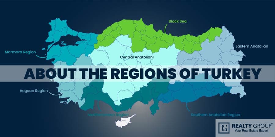
When it comes to learning about the regions of Turkey you are at the right place. Turkey’s region of the world is magnificent with its 7 geographic regions. These 7 regions of Turkey include cities that are similar to each other in terms of human, climate, geographical location, population settlement, and economic characteristics and have been created as a result of various studies.
Below you will find detailed information about the regions of Turkey:
1. Marmara Region
Turkey is a country that has hosted the oldest civilizations in the Anatolian region. The Marmara Region is a region located in the western part of Turkey, comprising the Thrace part and the lands in Anatolia. This geographical location separates the straits from the Sea of Marmara and constitutes approximately 8 percent of the country. Marmara is an inland sea located between Istanbul and Bursa and has been used for important strategic plans over the years. This region is a complete transition zone in terms of climate and vegetation, so it has milder climatic conditions compared to all other regions. In addition, a quarter of the country’s population lives in this region. Also, by clicking the Realty Group Project, easily examine the stylish houses in Istanbul in this region.
What are the Cities in the Marmara Region?
Connecting Asia and Europe, this unique region is home to 11 cities and 155 districts. The province with the largest area among these provinces is Balikesir, while the smallest area is Yalova.
Below, we have listed the cities in the Marmara region one by one for you:
- Balikesir
- Edirne
- Canakkale
- Bursa
- Bilecik
- Istanbul
- Kirklareli
- Sakarya
- Yalova
- Tekirdag
- Kocaeli
While considering the population density of these provinces, Istanbul is the most populous city in the Marmara region. Besides, the province with the least population in the Marmara region in Yalova.
What are the Seasonal Characteristics of the Marmara Region?
The geographical regions of Turkey are separated in an order which is dependent on climatic conditions and human factors. The Marmara region is located at the intersection of the Mediterranean climate and the Black Sea climate. It has a milder climate in the coastal provinces, while a steppe-type climate prevails in rural areas.
Since this region is under the influence of several different climatic structures, it has succeeded in being the region with the highest soil fertility. In addition, thanks to this climate structure, tourism is also quite developed. The southern Marmara coasts have a milder climate like the Mediterranean-type climate but the effect of continentality increases as you go to the inner parts. For this reason, there is a great variety of plants grown in the Marmara region.
What are the House Prices in Marmara Region?
Since Marmara Region is the most developed industrial region of Turkey, house prices are higher than in other regions. In addition, since the city of Istanbul is in the Marmara Region, the Marmara region is the region where you will find the most expensive house prices. The price of houses varies depending on many features. For example, the size of the house, its location, and its proximity to public transportation are also very important for house price determination in Turkey. The houses you will buy can start from 200 thousand dollars and reach up to a million, but when you look at smaller cities, you can find more affordable houses in beautiful buildings.
The best-selling house models in Turkey are in the form of 2 rooms, 1 living room, or 3 rooms and 1 living room. 1 room, 1 living room, or studio apartment models are designed for single people. If you want to examine the house prices in this region in more detail, you can interact with the Realty group.
Which is the Most Populous City in the Marmara Region?
There are eleven cities and 155 districts in the Marmara Region. Istanbul is the most populous city in Turkey and is located in the Marmara region. For this reason, a significant part of the total population in the Marmara region is located in Istanbul.
2. Mediterranean Region
The Mediterranean Region, another region that takes its name from the sea with which it is adjacent, has an area of 120,000 square kilometers and is the 4th largest region in terms of both population and area. The Mediterranean climate type is experienced in 8 provinces located in the Mediterranean Region. In addition to these 8 provinces, the Mediterranean region is home to 104 districts.
Tobacco, wheat, rice, tobacco, cotton, banana, citrus fruits, olives, pineapple, poppy, rose and sugar beet are grown in this special region, which is Turkey’s tourism paradise. Check by clicking the website, to find awesome products by Realty Group Project.
What are the Cities in the Mediterranean Region?
Below you can find the list of the cities in the Mediterranean Region.
- Adana: Adana, the sixth most populous city in Turkey, is famous for its high temperatures in summer. It is also one of the country’s leading agricultural, commercial and cultural centers.
- Antalya: It is the fifth most populous city in Turkey. Antalya is also the city that hosts the most number of tourists in the country. It continues to be a popular city in both summers and winters with its hot and dry summers and warm and rainy winters.
- Burdur: Burdur is a more rural province and generally a city where agriculture and animal husbandry are carried out. An important feature is that it is located in the lakes region.
- Osmaniye: Osmaniye is a Mediterranean province that became a city after the district. In addition, one of the features of this province is that it meets about 80% of the country’s needs in peanut and radish production.
- Hatay: Hatay, neighboring Syria, has an important place in the Mediterranean region and is also a city surrounded by the Amanos Mountains.
- Isparta: The city of Isparta, located in the Lakes Region, is famous for its rose cultivation.
- Mersin: Mersin is a port city that deals with Tourism, Industry, and Maritime. It is also the country’s eleventh most populous province.
- Konya: Konya is Turkey’s largest province in terms of area and the seventh most populous city. Catalhoyuk, the oldest settlement in the world, is within the borders of this city.
- Kahramanmaras: While Kahramanmaras, formerly known as Maras among the people, ranks 18th in the country in terms of population, the most important feature is that the Elbistan thermal power plants in this city meet 14% of Turkey’s electricity needs.
- Karaman: While a part of the city of Karaman is in the Mediterranean region and adapts to its climate, another part is located in the Central Anatolian region. In this way, it is a province located in two regions.
- Afyonkarahisar: Afyonkarahisar is a unique province that spreads to two different regions, such as the province of Karaman.
- Denizli: Denizli, which is one of the most developed provinces of the country in the fields of industry, trade, agriculture, tourism, education, culture, and art, is famous for its Denizli rooster.
- Gaziantep: Gaziantep, popularly known as Antep, is a province of Turkey and the ninth most populous province. This city, which is famous for its food, is also very famous for its agriculture in the country.
- Nigde: Nigde is a city that has two different climate types with its lands located in both Central Anatolia and the Mediterranean region.
What are the Seasonal Characteristics of the Mediterranean Region?
The Mediterranean region is a region that includes the cities of the country located entirely on the southern coastline. Therefore, the type of climate felt is the Mediterranean climate. In this climate type, summers are hot and dry, while winters are rainy and warm. The average annual temperature is 18 Celcius degrees. This offers a wonderful atmosphere for tourism.
What are the House Prices in Mediterranean Region?
The real estate market in Antalya, the capital of tourism, and in other cities in the Mediterranean region has gained a rapid acceleration compared to previous years. While the population of the city exceeds 1 million, house prices in the city have increased significantly in the last 5 years. For example, 5 years ago, an average house was sold at prices between 50-60 thousand dollars, but now the average is 250 thousand dollars.
Which is the Most Populous City in the Mediterranean Region?
The population of the Mediterranean Region is approximately 2 million 980 thousand. There are a total of 8 cities and 104 districts in the region. Its most populated cities are Antalya and Adana.
- Antalya: It is the 6th most populous city in Turkey. With an area of 1,417 square kilometers, the most populated districts of Antalya are Kas, Alanya, and Kepez; The district with the least population is İbradı. There are 19 districts in Antalya.
- Adana: Its surface area is 1,945 square kilometers. The fact that the city has a lot of job opportunities is the biggest factor in internal migration. There is a cotton cultivation area of 450 thousand decares in the city. The most populated districts of Adana are Seyhan, Ceyhan, and Kozan, respectively. It borders with Hatay, Osmaniye and Mersin.
3. Aegean Region
Aegean region, which covers approximately 11% of Turkey’s territory, is adjacent to the Marmara Region in the north, the Central Anatolian Region in the east, the Mediterranean Region in the southeast, and is surrounded by the Aegean Sea in the west, which takes its name from this sea.
In terms of population density, it ranks second after the Marmara Region. More than half of the region’s population lives in cities. When examined in detail, the population is dense in the plains, and the population is sparse in the mountainous areas that separate the plains.
The Aegean Region is generally under the influence of the Mediterranean climate, which is hot and dry in summers and mild and rainy in winters. This general situation is mostly valid for the Aegean Region. In Inner-Western Anatolia, on the other hand, there is a change in climatic conditions due to the distance from the sea and the altitude. Cold raids are common in the northern parts.
The most important thing in the vegetation of the region is that it is a pine nut production area. In addition, olive groves are found in all coastal areas. Protected from the cold weather effects from the north, citrus fruits grow in the south of the region. In addition, fragrant herbs such as thyme, sage, lavender flowers, and cacti that fit the Mediterranean climate are common in plants such as frankincense. Realty group actively provides home buying and rental services to esteemed people like you in this beautiful region. If you wish, you can go to the Realty Group project tab to look at the stylish houses.
What are the Cities in the Aegean Region?
Aegean Region, consists of two parts: Inner West Anatolia and Coastal Aegean. Let’s examine the cities in the Aegean region, which is the 5th largest region of Turkey in terms of area, together;
- Mugla: It is one of the cities that attract the most number of tourists in the Aegean Region. The most populated district in Fethiye.
- Izmir: It consists of 30 districts in total. The most populated cities are Cesme, Karsiyaka and Buca.
- Aydin: There are 17 districts in total in Aydin. Kusadasi and Didim are the districts that attract the most tourists.
- Afyon: It is the largest city in the Aegean Region in terms of surface area. The city, which has a total area of 14.23 square kilometers, has 18 districts. The most populous district is Sandikli.
- Denizli: Denizli consists of 19 districts in total. The most populated town is Pamukkale, which is famous for its travertines. Pamukkale, with a population of approximately 340,000, has developed nature and health tourism.
- Manisa: Its surface area is 1,232 square kilometers. Its most populous district is Yunusemre.
- Kutahya: Porcelain industry in the city is quite developed. Kutahya is adjacent to the provinces of Bursa, Bilecik, Balikesir in the Marmara Region and Konya and Eskisehir in Central Anatolia.
- Usak: It is the smallest city in the Aegean Region in terms of surface area. It consists of 6 districts in total
The populations of these provinces are listed as follows, according to the latest census;
- Izmir – 4 million 320 thousand
- Aydin – 1 million 100 thousand
- Denizli – 1 million 30 thousand
- Manisa – 1 million 45 thousand
- Mugla – 984 thousand
- Afyon- 725 thousand
- Kutahya – 578 thousand
- Usak – 367 thousand
What are the Seasonal Characteristics of the Aegean Region?
The dominant climate type in the Aegean Region is the Mediterranean Climate. In the climate of the region, summers are hot and dry, while winters are rainy and warm. Mediterranean climate is more common on the coast than inland.
In this way, the Aegean Region has become one of the most important regions of the country. Agriculture, animal husbandry, industry, trade, and tourism are highly developed. Health, education, and legal services are also at a high level.
What are the House Prices in Aegean Region?
Real estate prices are increasing day by day in the Aegean region due to its magnificent weather and developed industrial zone. Housing sales prices in the Aegean have increased by 53 percent in the last 1 year and by 149 percent in the last 4 years.
The city with the highest increase rate in the real estate market in the Aegean Region is Kusadasi. For more detailed information, you can search the cities in this region.
Which is the Most Populous City in the Aegean Region?
The Aegean Region, with a surface area of 90,251 square kilometers, is Turkey’s 5th largest region. It consists of two parts, “Inner West Anatolia” and “Coastal Aegean”. The population of the Aegean Region, which has the longest coastline of our country, is approximately 10 million 320 thousand. İzmir, the 3rd most populous city of Turkey, is the largest city in the Aegean Region.
4. Central Anatolian
Central Anatolia Region is one of the 7 regions of Turkey, located in the central Anatolia region of Turkey. Because of this location, it is also called “Central Anatolia”. It is adjacent to all other regions except the Southeastern Anatolia Region. The most important part of the Central Anatolia region, which has been popular lately, is the Cappadocia region of Turkey. A visual feast reminiscent of a fairy world awaits you in Cappadocia. This region is also famous for its granary. The Central Anatolia Region is divided into four parts:
- Konya Division
- Upper Sakarya Division
- Middle Red River Section
- Upper Kizilirmak Division
This special region, consisting of mountains and plains, meets a large part of the country’s agricultural needs. Let’s look at the cities in this region.
What are the Cities in the Central Anatolian?
The Central Anatolian region covers a large area of the country in terms of surface area, so it is home to a variety of cities. Based on the provincial centers, the 13 provinces within the borders of the Central Anatolia Region are as follows:
- Ankara
- Konya
- Kayseri
- Eskisehir
- Sivas
- Kirikkale
- Aksaray
- Karaman
- Kirsehir
- Nigde
- Nevsehir
- Yozgat
- Cankiri
The populations of the provinces in the Central Anatolia Region are as follows according to the last census;
- Ankara – 5 million 505 thousand
- Konya – 2 million 206 thousand
- Kayseri – 1 million 390 thousand
- Eskisehir – 872,000
- Sivas – 648,000
- Yozgat – 425,000
- Aksaray – 413,000
- Nigde – 365,000
- Nevsehir – 298,600
- Kirikkale – 286,500
- Karaman – 252,000
- Kirsehir – 242,000
- Cankiri – 217,000
What are the Seasonal Characteristics of the Central Anatolian?
Since the region is surrounded by high mountains, the humid temperate air of the seas cannot be brought into the region. For this reason, the region has a continental climate with hot and dry summers and cold and snowy winters. In the region, the degree of continentality increases due to the increase in height towards the east, and the winter temperatures reach very low values.
The Central Anatolian region receives the most rainfall in the spring months. The driest season is summer. Precipitation in the region is of convectional and frontal origin. Convectional precipitation, also called Kirkikindi, is common in Spring. The vegetation is steppe.
What are the House Prices in Central Anatolian?
With the depreciation of the Turkish lira against the Dollar, a certain rate of increase began to be experienced in every sector, but real estate broke the record as the sector that received the highest increase. In the Central Anatolia region, house prices increased by 5 to 20 percent compared to last year, due to the population and social power, and economic power. However, compared to cities such as Istanbul and Izmir, the Central Anatolian region includes our relatively more affordable cities.
Which is the Most Populous City in the Central Anatolian?
Central Anatolia is the second largest region of Turkey after the Eastern Anatolia Region. Konya, which is the largest city in our country in terms of surface area, is located in this region. The most populated city is Ankara. Ankara is also the second most populous city in Turkey.
5. The Black Sea
The Black Sea Region is one of the seven geographical regions of Turkey, named after the Black Sea, on which it is a coast. This region, which ranks third in terms of size, is also the region with the largest local time difference. In addition, the Black Sea consists of 3 separate parts;
- Western Black Sea Division
- Central Black Sea Section
- Eastern Black Sea Section
This region covers 18% of Turkey’s land with a real area of 122,121 km². The region resembles a lane with 1400 km in the east and west direction and 100–200 km in the north and south directions.
What are the Cities in the Black Sea?
There are 18 cities in the Black Sea Region. Among these cities, the province with the most districts is Kastamonu, and the province with the fewest districts is Bayburt. Let’s see the Black Sea provinces;
- Artvin,
- Rize,
- Bayburt,
- Trabzon,
- Gumushane,
- Giresun,
- Ordu,
- Tokat,
- Amasya,
- Samsun,
- Sinop,
- Corum,
- Kastamonu,
- Bartin,
- Karabuk,
- Zonguldak,
- Duzce
- Bolu
What are the Seasonal Characteristics of the Black Sea?
The climate that dominates the Black Sea Region is called the Black Sea climate. It is possible to list the characteristics of the Black Sea climate as follows.
- It is rainy almost every season.
- The season with the highest precipitation in the Eastern Black Sea region is Autumn. Annual precipitation amounts can vary between 2000 and 2500 mm.
- In the Central Black Sea region, the season with the highest precipitation is winter, while the least precipitation falls in summer. The annual precipitation average can vary between 1000 and 1200 mm.
- In the Western Black Sea region, the season with the highest precipitation is Autumn. The least precipitation falls in the Spring season. The average precipitation can vary between 1000 and 1500 mm on average annually.
What are the House Prices in the Black Sea?
While it is stated that a brand-new house in Trabzon starts from at least 100 thousand dollars and reaches millions, the reason why foreign citizens have recently shown interest in this region is both the clean air and the more attractive prices compared to other regions. If you want to buy a house in this region, you can make an agreement with a real estate agent and make a house tour and get a quotation.
Which is the Most Populous City of the Black Sea?
The Black Sea Region is one of the seven geographical regions of Turkey, named after the Black Sea, stretching from the east of the Sakarya Plain to the Georgian border. It occupies the third place in terms of size among the regions in Turkey, it is also the region with the largest east-west width and therefore the local time difference. The largest and most developed cities of the Black Sea Region are Samsun, followed by Trabzon and Ordu with a total population of 1,250,076, respectively. West Blacksea; Since it is flatter than the Central and Eastern Black Sea region, the population is scattered here. In the Middle and especially in the Eastern Black Sea Region, the population is dispersed collectively due to the high roughness and altitude.
6. Eastern Anatolian
Eastern Anatolia Region is one of the seven geographical regions of Turkey. It was named as such by the First Geography Congress in 1941 due to its location in the east of Anatolia. There are 14 provinces and 125 districts in total within the borders of the Eastern Anatolia Region. The largest city in terms of the surface area is Erzurum, while the smallest is Igdir. This region is the largest region of Turkey in terms of area. In addition, Lake Van, Turkey’s largest lake, is also located in this region. However, since the composition of the water of the lake is soda, it is not suitable for fishing. The vegetation of the region is steppe in low areas and forested areas in high areas. Most of the population is concentrated in the plains.
What are the Seasonal Characteristics of the Eastern Anatolian?
The climate in the region is continental. Steppe vegetation is seen only in two provinces, Elazig and Malatya. Thanks to the effect of Lake Van, the districts of Bitlis and Van provinces on the shores of Lake Van have a temperate climate. The severe type of continental climate is located in the eastern Anatolia region. So, summers are short and cool. Winters are long and quite cold. The lowest temperatures in Turkey are seen in this region. This type of climate affects agriculture negatively.
The main livelihood of the region is cattle breeding. Livestock trade and animal products are common. Agriculture can be done in areas where the climate is favorable. It is the richest region in terms of minerals.
What are the House Prices in Eastern Anatolian?
Although house prices in more developed provinces such as Erzurum and Van are higher, in general, house prices in the east are more affordable than in the western part. For this reason, homebuyers often prefer these regions for investment purposes. For detailed information, you can contact us and get information.
Which is the Most Populous City in the Eastern Anatolian?
Eastern Anatolia Region is the region with the lowest population density in Turkey. The main factor in this is the large area of the region. According to the census in 2021, the population of the region is around 6 million 513 thousand 106 people. There are 14 provinces in Eastern Anatolia. The province with the highest population is Van.
7. Southern Anatolian Region
The Southeastern Anatolia Region, which is the smallest region of Turkey in terms of land, is one of the seven geographical regions. It covers the areas from the south of the Southeast Taurus Mountains to the Syrian border. The region is surrounded by the Eastern Anatolia Region in the east and north, the Mediterranean Region in the west, Syria in the south, and Iraq with a short border.
This piece of land constitutes 8% of Turkey’s land. The climate is dry in the summer months, and rainy and warm in the winters. To examine it in more detail, we need to know which cities are located in this region.
What are the Cities in the Southern Anatolian Region?
Southeastern Anatolia Region, where Turkey’s flattest areas are located, has a total of 9 provinces. The total number of districts in the region is 80. The largest city in terms of the surface area is Urfa, while the smallest is Kilis.
The provinces of the Southeastern Anatolia Region are listed as follows.
- Adiyaman,
- Batman,
- Diyarbakir,
- Gaziantep,
- Kilis,
- Mardin,
- Sanliurfa,
- Siirt
- Sirnak
What are the Seasonal Characteristics of the Southern Anatolian Region?
The weather is dry in summer, rainy, and warm in winter. Compared to the Mediterranean climate, winters are colder and summers are warmer. The natural vegetation of the region is the steppe. It is poorer compared to the steppes of Central Anatolia. It covers a large area in the anthropogenic steppes in the region.
What are the House Prices in Southern Anatolian Region?
Contrary to other regions, house prices are quite affordable in Southern Anatolian cities. Therefore, people, who want to invest in the future find it appropriate to invest in real estate by buying a house in this region. For houses in this area, you can talk to a local real estate agent and tour the house or contact us.
Which is the Most Populous City in the Southern Anatolian Region?
One of the 7 regions in Turkey, the Southeastern Anatolia region consists of 9 provinces. Southeastern Anatolia Region is the smallest region of Turkey in terms of surface area. Covering an area of 59,176 kilometers, there are 9 provinces in the region. There are 3 cities in the region with a population of over 1 million. These cities are Sanlıurfa, Gaziantep and Diyarbakır. The most populated province is Gaziantep with a population of 1,844,438.